
Recent housing development in Harrogate District has been a disaster zone as far as active travel is concerned.
Nearly all the sites in Harrogate and Knaresborough are on the edge of town, but do not include any useful cycle infrastructure.
The ‘jug handle’ pictured above is a good example. To reach it, you would have to cycle along the very busy A61 to Pannal. Then the designers imagine you’re going to use their 12m long path in order to lose priority as you negotiate the roundabout by the development.
It is nonsense – a token gesture by designers who either don’t know anything about travel by bike, or aren’t interested in making it possible.
4.1) NPPF and Active Travel as the 1st Priority in New Developments

Developers and NYC Highways Development Control officers do not even acknowledge the rule that states that they should give priority to active travel in new developments – so there is no chance of them applying it.
They say that their job is to “balance the interests of all road users”. They are deliberately and explicitly failing to apply the rule from NPPF.
The next problem is that by “balance the interests of all road users” they actually mean “provide exclusively for motor vehicles”.
At the West Harrogate Urban Expansion (see below), provision on the site itself appears to be an improvement on other recent developments, but the wider Transport Strategy is a disaster. It contains warm but insincere words about sustainable travel. The specific plans are for capacity increases for cars across a large swathe of Harrogate.
4.2) Some Recent and Current Housing Development Sites

4.2.1) Killinghall
Killinghall is the fastest expanding village in North Yorkshire. It’s not within easy walking distance of Harrogate, but the distance (about 2 miles) could be done by bike – if there were a safe route.
Neither of the options – A61 or B6161 – are viable without segregated infrastructure, as they are very busy and hostile roads. There isn’t even a link to the Nidderdale Greenway, which is a stone’s throw from Killinghall.
It is disgraceful that NYC has allowed a major expansion of Killinghall with no new active travel infrastructure.
Local residents including parents have been fobbed off and dismissed by Councillors and officers.
After months of persistence by one of our members, we arranged a site meeting with NYCC officers to discuss using a small sum of s. 106 money (£65,000). This resulted in an agreement to do some small works:
- widen the Nidderdale Greenway at the Killinghall end and
- put in a raised table and priority crossing for the Greenway in Bilton
Our reservations about this are:
- the work was supposed to happen in 2022/23 but as usual there has been delay after delay. At the beginning of 2025, no work has started
- these are small improvements that do not provide a safe link from the village to the greenway, nor a direct cycle route from Killinghall to Harrogate
4.2.2) Castle Gate and Trinity Fields

Castle Gate and Trinity Fields are on the eastern edge of Knaresborough – within an easy cycling distance of the High Street.
Developers have been allowed to get away with some ludicrous and pointless narrow bits of cycle path for a few metres near a couple of roundabouts. The “infrastructure” then dumps you back onto the busy main road. There is no safe link to the town centre.
In breach of LTN 1/20 guidance, the developments themselves have shared use pavements that give way to minor side roads.
On active travel, it is a fail.
4.2.3) Kingsley Drive
There are housing developments off Kingsley Road, north of Kingsley Drive, and east of Claro Road.
Developers consulted on a scheme to make Kingsley Drive one-way. We put a lot of effort into liaising with officers and suggesting contraflow cycling. After months of chasing up to try to get an answer, the whole scheme was dropped without reference to us.
The developments will increase traffic on residential roads in the area.
We asked for double yellow lines on one side of Kingsley Drive, to prevent parking there. NYC refused, saying they would take a “wait and see if it’s a problem” approach.

Inevitably, it is a problem. It will be a problem that is much harder to solve once people have bought the new houses, moved in, and got used to parking their vehicles on the pavement.
4.2.4) Bellway Pannal

This is a development on the old Dunlopillo site at Pannal. It has the ridiculous “jug handle” pictured at the top of the page at its roundabout junction with the A61.
There are shared use pavements in the development itself, but nothing beyond the development’s junctions with the A61.
There was a s.106 agreement that obliged the developer, Bellway, to pay for a cycle route along the A61 from Almsford Bank to the junction with Fulwith Mill Lane. However, HBC voluntarily released Bellway from its obligation on the basis that the cycle track would be too expensive, accepting £189,00 instead – around 20% of the cost of a cycle route.
NYCC is apparently looking into cycle infrastructure, and/or Park & Ride and bus lanes, on the A61 south. This is called the Harrogate Transport Improvment Plan (HTIP), and it has been going on since the Congestion Survey reported in 2019.
So far, the council has spent 5 years and nearly half a million pounds on HTIP, but there are no results at all in on-the-ground improvements and no prospect of any on-the-ground improvements.
The West Harrogate Urban Expansion include proposals to expand capacity for motor vehicles at junctions on the A61, and those proposals ignore HTIP altogether.
It feels as though sustainable transport proposals in HTIP are entirely theoretical (an “aspiration”, to use local authority terminology for something that is never going to happen), but expansion of capacity for motor vehicles will just get bulldozed through in short order, creating new facts on the ground.
Meanwhile, urban sprawl is taking place between Harrogate and Pannal. A drive-thru coffee shop has been built, and Crimple Hall has added a Food Hall to its existing Garden Centre, with a vast car park.
4.2.5) West Harrogate Urban Expansion

A very large number of houses are likely to be built by the B6162 Otley Road out towards Beckwithshaw.
NYC’s Transport Strategy for West Harrogate is a car-centric disaster.
It contains a lot of warm words about sustainability in West Harrogate, but they are meaningless. The specific transport proposals are 100% the ‘predict and provide’ model of car-centric development, with capacity expansion for motor vehicles at 30 junctions. NYC will take all the space at those junctions for cars, leaving no space for cycling infrastructure.
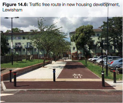
Within the developments themselves, it does appear that there will be proper cycle tracks by the roads. Paths away from streets are likely to be shared use, but it would be better to follow best practice shown in Fig 14.6 of LTN 1/20.
“Phase 3” of Otley Road Cycleway is planned as shared use, in breach of LTN 1/20 guidance.

The cycleway will not reach Harrogate town centre because NYC refuse to build “Phase 2”.

4.2.6) King Edwin Park
This is yet another 100% car-centric development, where developers have been allowed to build without providing any meaningful cycling connections to key destinations.
There’s a shared use pavement (2m70 wide) for a few metres along Penny Pot Lane near the site, which then stops. This is token provision which does not go anywhere.
There are also some mud and gravel paths across Killinghall Moor Country Park, but no sign of them being upgraded.
The junction with Penny Pot Lane is worth a mention: it’s 83m (EIGHTY-THREE METRES) wide, making it suitable for high-speed turns into the development by drivers, but dangerous for those on foot. Presumably HBC and NYCC were asleep at the wheel when they approved this design.

There shold be tight kerb radii at residential side roads to reduce vehicle speeds.

This correspondence with HBC covers the main cycle infrastructure issues at King Edwin Park.
We have also learned that as part of Phase 2 of the development, a bus-only route is to be built to link King Edwin Park to Jennyfield.
LTN 1/20 is clear that a parallel cycle track is to accompany any bus-only route.

Will NYC insist that the developers build a parallel cycle track? It is very unlikely.
4.2.7) A59 Skipton Road

This is a vast development by several developers.
The only active travel infrastructure is a path (shared use again) along the front of the development. Unfortunately, it doesn’t go anywhere – not even to the nearest shops at Oak Beck Park.
NYC’s LCWIP includes a route via Crowberry Drive and Jennyfield Drive – an ideal candidate for upgrade in connection with this development. Unfortunately, it is not happening.
It reflects an attitude that once the LCWIP document has been written, that’s job done without actually going on to build any of the routes mentioned in the document. As far as the council is concerned, the report is the final outcome of the work – not on-the-ground improvements.
There have been no steps towards building the four main routes in the LCWIP since it was adopted by NYCC in 2019.
4.3) Active Travel England
If Active Travel England (ATE) visit any of these developments, they will get a good idea of the ongoing failure to make active travel a realistic option for residents, let alone the first priority (NPPF) or the natural first choice (CWIS).
If ATE want to make a difference for the future, grilling NYC about their plans for the West Harrogate Urban Expansion and then asking them to improve the plans, would be the best way to make a start.
Please tell them that when LTN 1/20 says shared use is a last resort, that means it’s a last resort not the default, preferred or only option.
ATE may have begun to make a difference to cycling infrastructure on the development sites themselves. So far, they do not appear to have influenced the bulk of the West Harrogate transport plans which are off site.