
North Yorkshire Council (NYC) is planning a major urban expansion in West Harrogate, and its Transport Strategy Part 1 and Part 2 has just become available.
In the Strategy there is no shortage of warm words about sustainable travel, but the concrete proposals fall woefully short of the rhetoric. They look likely to lead to (more) carmageddon in Harrogate.
TL;DR
NYC claims to be following a ‘decide and provide’ strategy.
Decide and provide would prioritise sustainable transport, and only increase capacity for motor vehicles as a last resort. By contrast, NYC’s Transport Strategy is very largely focused on expanding capacity for motor vehicles.
It looks as though there will be some cycling and walking paths within the West Harrogate developments, but they won’t connect to the town centre or other key destinations.
The Otley Road Cycleway is fatally flawed because of the council’s decision to cancel Phase 2 from Cold Bath Road to Beech Grove, and to rip out the Beech Grove modal filters.
Meanwhile, at a huge number of junctions across a wide area of Harrogate the council plans to increase capacity for motor vehicles without doing anything for cycling – and indeed taking all the space that would be needed for cycling facilities.
NYC’s Transport Strategy for West Harrogate is the same old predict and provide for motor vehicles, masquerading as decide and provide.
1) Decide and Provide
The Transport Strategy claims that it represents a ‘decide and provide’ approach (para 8.5.3).

‘…reducing the need to travel, discouraging individual private vehicle journeys, and making walking, cycling, public and shared transport the natural first choice’.
They key features of decide and provide are:
- prioritising active and sustainable travel by making high-quality provision that enables modal shift, and
- not increasing capacity for motor vehicles except as a last resort
Looking at the details of the alleged decide and provide approach (Appendix 13 of the Transport Strategy), it appears that NYC are using the term in one very narrow sense – as a way of justifying reducing their motor vehicle trip generation forecasts.
Looking at the substantive content of the Transport Strategy, the council is not prioritising active and sustainable travel in a way that would lead to modal shift. On the contrary, NYC is increasing capacity for motor vehicles (and in doing so, taking space that could otherwise be used for cycling facilities).
Regional Planning Policy Principles
In his position on the Leaders Board of Yorkshire & the Humber Climate Commission, NYC Council Leader Carl Les has signed up to Regional Planning Policy Principles. Among the principles is implementing modal shift in travel – ‘aligning planning policies to ensure that public and active modes become the most attractive choice for a much larger share of journeys’.
The Council Leader’s high-level commitment to sustainable travel in new developments does not appear to have resulted in changes to the way NYC Development Control officers work in practice.
2) Paths Within Developments

There are to be some paths within the developments.
Facilities like schools and local shops are promised, so if the paths are built to good standards they will be useful for very short trips to those destinations.
H51 Banks

Details on the H51 Banks planning application suggest that cycle infrastructure within the developments will be built to modern standards:
- by the road within the development there is a cycle track with priority over side roads
- separate footway
- away from the road, there is to be a 3m shared use path
See a plan showing the proposed shared use path in purple.
It looks as though Active Travel England has got through to developers and explained the standards required of them.
At the boundary of the development, potential cyclists are thrown back onto the existing road network, which is hostile to cycling.
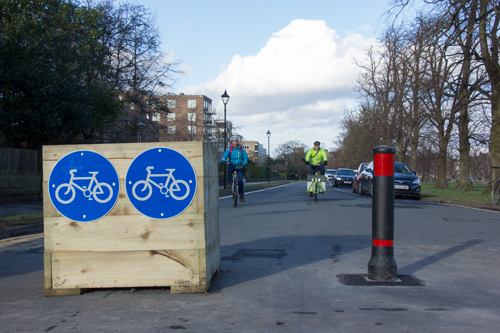
3) Otley Road Cycleway

High-quality cycling facilities would be a key part of a decide and provide Transport Strategy.
The Transport Strategy says (para 3.2):
‘The ability to be able to walk and cycle within the West of Harrogate Sites and further afield to essential services and work is key in order to minimise traffic’.
The most important cycle link from West Harrogate is to the town centre. Para 1.2.7 of Appendix 13 claims that the Transport Strategy will provide such a link.

Unfortunately that is simply not true, since NYC is refusing to build Phase 2 of Otley Road Cycleway.
Transport Strategy Undermined by Decision to Cancel Phase 2
Otley Road Cycleway will not reach the key destination – the town centre. It will have a broken link where Phase 2 (and Beech Grove) should be. Phase 2 was funded and ready to go, but NYC cancelled it.
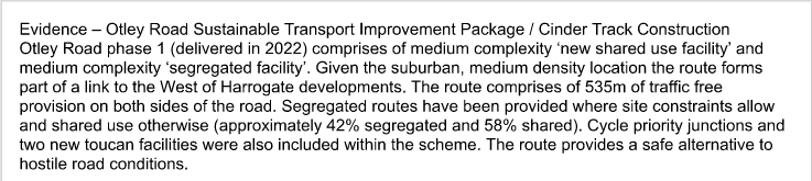
NYC itself, in its active travel capability self-assessment 2024, describes Phase 1 of Otley Road Cycleway as ‘a safe alternative to hostile road conditions’.
Yet NYC expects people to cycle in those hostile road conditions on the sections of Otley Road where it refuses to build a cycleway. Most people won’t do it.
The video below shows cycling on the section of Otley Road where Phase 2 should have been.
The decision to cancel Phase 2 of Otley Road Cycleway undermines the whole of the cycling strategy for West Harrogate.
Phase 3 of Otley Road Cycleway
NYC says they plan to build Phase 3 of Otley Road Cycleway as a priority.

According to their response to our FOI request, it may be built in Summer 2025 if their bid to Homes England’s Brownfield Infrastructure & Land Fund is successful. If not, construction may be funded by s106 money and start in Autumn 2025/Spring 2026.
Phase 3 ought to be a cycle track separate from the footway not shared use.
NYC say:
‘Because of constraints on the adopted network it will be shared use. Design work within the developer controlled land (H49) and linkages into adjoining developer sites still ongoing, but aiming for segregated use’.
The claim that constraints prevent NYC building a cycle track and separate footway is disingenuous.
A footway and separate cycle track would be 3.5m wide, and there is enough space for that without cutting down any trees.
Active Travel England
Active Travel England (ATE) advised NYC about Phase 3 of Otley Road Cycleway on 18th May 2023. The main points were:
- shared use is unlikley to see as significant an uptick in active travel when considering the planned large scale residential development
- shared use facilities are typically only acceptable as a last resort in constrained locations where all options to provide a segregated facility have been found to be unfeasible
- provision of a segregated facility at 3.5m should be the preferred option
ATE advised NYC to take both design options further to determine the viability of segregated provision.
NYC ignored this advice, and proceeded with design work on shared use only.
Note also that ATE apparently provided a few words of advice about Phase 2 of the cycleway, which had already been cancelled. It appears that NYC misled them, or failed to correct their erroneous impression, about Phase 2.
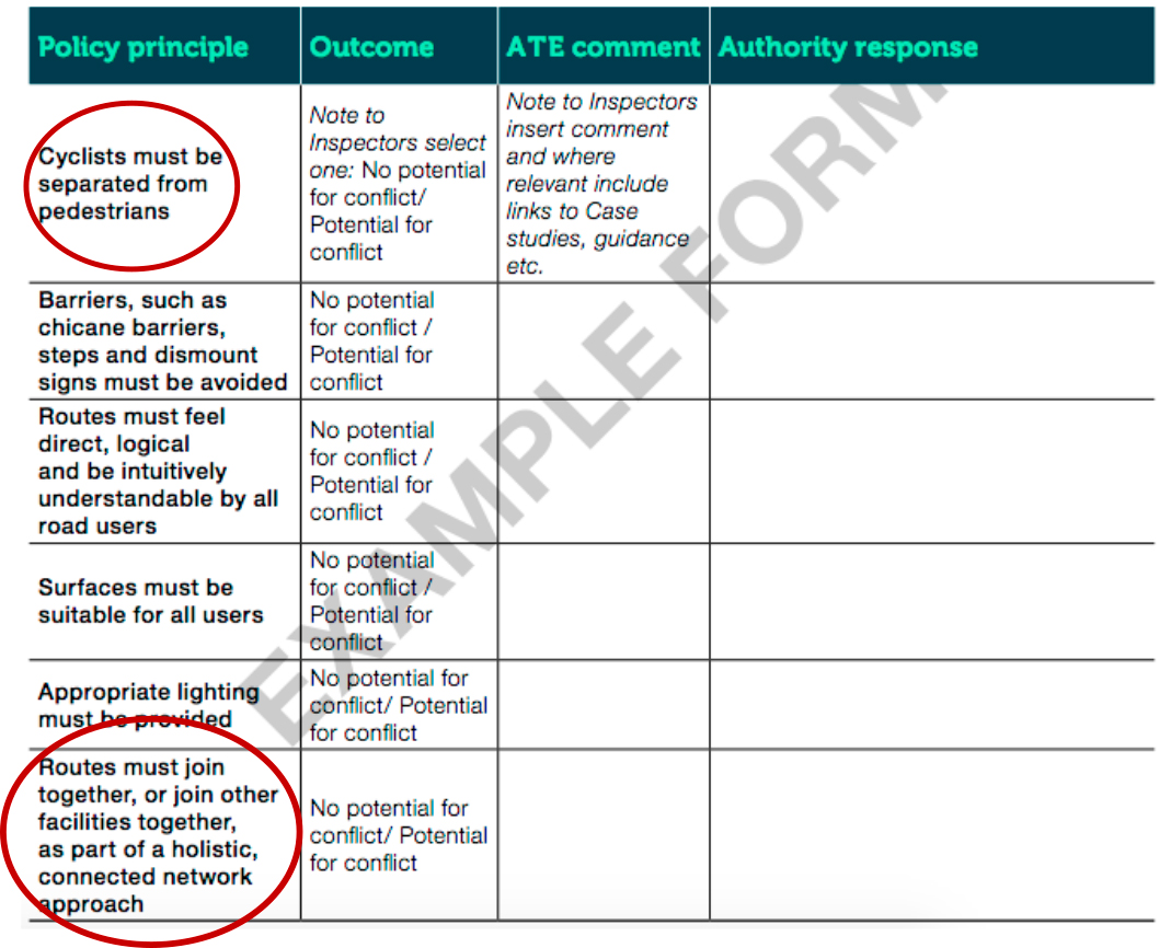
ATE have recently set out their procedure for inspecting completed schemes. The form makes clear that shared use and routes that don’t join up are breaches of policy principles.
4) Trinity Road

NYC is proposing to expand capacity for motor vehicles at the bottom of Otley Road by turning Trinity Road into an officially-designated rat run.
The plan is to put traffic lights at either end of Trinity Road, on Otley Road and Leeds Road, and to direct traffic to cut the corner via Trinity Road instead of going via Prince of Wales roundabout.
That would change Trinity Road from a quiet park/residential street into part of the main road network.
Trinity Road as a Cycle Link
Instead of NYC’s high-traffic scheme, we suggest a modal filter on Trinity Road, to prevent its use by through traffic. It could then provide a quiet street link between future Leeds Road and Otley Road cycle facilities.

NYC Offering Only Advanced Stop Lines at Traffic Lights for Cycling
When challenged about Trinity Road, NYC said:
‘The highways authority/planning authority must strike a balance between bringing forward new development and mitigating its impact on users of the highway network.
We all know that vehicle use will not cease overnight and whilst sustainable and active modes of travel are a key consideration in achieving this aim, so too is the need for a safe and relatively free-flowing road network.
The Trinity Road scheme can aim to achieve both as it helps reduce congestion, it provides traffic signals with pedestrian phases to help cross the A61 and Otley road, signals can be provided with advance stop lines for cyclists’.
NYC is proposing to grab more space for motor vehicles and provide no safe space for cycling. This does not amount to “striking a balance” in the council’s glib remark – it is prioritising motor vehicles.
Advance stop lines for cyclists do not amount to adequate provision on Leeds Road and Otley Road. They assume that people on bikes will ride in mixed traffic on a busy main road.
LTN 1/20 Cycle Infrastructure Design says that cycling in mixed traffic is only suitable on quiet roads (maximum 2,500 vehicles a day) and up to 20mph. It insists on segregated cycle tracks on busy main roads.
Advance stop lines are inadequate provision on Leeds Road and Otley Road; and Trinity Road will become unsuitable for cycling if NYC follows through on its plan to create hostile road conditions there.
A-E Scale of Commitment to Active Travel
There is a scale of commitment to active travel, A to E, which is widely used including by Oxfordshire County Council and in York’s Framework for a Movement and Place Plan.
This is Oxfordshire’s version.

This is City of York Council’s version for its Movement and Place Plan.
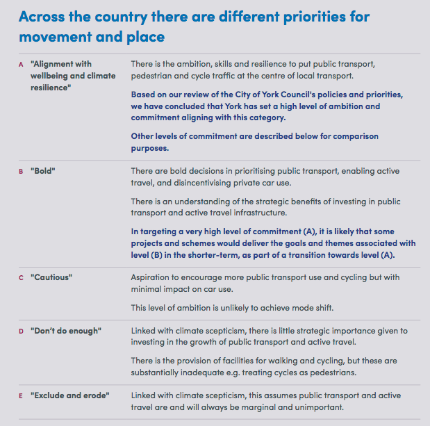
A and B are the most ambitious levels.
At the other end of the scale:
- D – don’t do enough. There is the provision of facilities for walking and cycling, but these are substantially inadequate, e.g. treating cycles as pedestrians
- E – exclude and erode. Linked with climate scepticism, this assumes public transport and active travel are and always will be marginal and unimportant
We can see where NYC’s proposals fall on that scale. In terms of traffic modelling, A ‘decide and deliver’ would involve multi-model models and motor traffic reduction.
NYC’s approach falls within D (meeting increase in car use which has been predicted in forecasts) or E (meeting high future forecasts in car use).

There are also descriptions of the A to E categories in relation to traffic circulation and the main road network.

‘Widening of junctions and increasing space for car traffic’ describes what NYC is doing. That is Level E.
In relation to signalised junctions and roundabouts, Advanced Stop Lines and shared use for some cycling and walking is Level D. Multi-lane entries and exits to junctions, with Advanced Stop Lines, is Level E.
NYC continues:
‘It may well be that the indicative design put forward for Prince of Wales/Trinity Road does not happen if the funding bid for HTIP is successful. If this is the case then monies secured from the developer s106 obligations for mitigation measures on the A61 corridor will be used as matched funding against bringing forward the overarching aims of HTIP’.
Sustainable transport improvements are always dependent on funding, but capacity increases for motor vehicles are not. Vague promises from NYC of possible future redesigns cannot be trusted.
5) Prince of Wales Roundabout and Crossing of Otley Road at Beech Grove

There has been a longstanding request for proper crossings of the arms of the Prince of Wales roundabout.
NYC have always told us to wait, because they will be included in the West Harrogate infrastructure works. Now we have seen the West Harrogate plans, and there are no Prince of Wales roundabout crossings there.
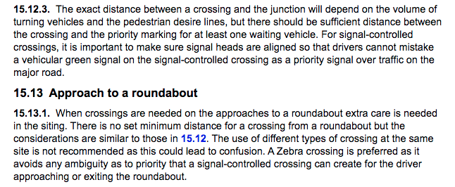
One excuse given by NYC is that crossings should not be put in right on the approach to a roundabout. This appears to be disingenuous. The DfT Traffic Signs Manual Chapter 6 says that the required setback is only one car’s length.
Note that where it says ‘new pedestrian crossing location’ on the plan, this does not appear to be a true pedestrian crossing, just some tactile paving indicating a suggested (dangerous) crossing point, with no priority for pedestrians.
Similarly, a crossing of Otley Road by the Beech Grove junction has repeatedly been promised as part of the West Harrogate plans, but it is nowhere to be seen in the Transport Strategy.
6) Pannal Ash Road and Whinney Lane

Appendix 17 of the Transport Strategy has some designs for Pannal Ash Road. Zebra crossings are proposed on the arms of the roundabout at the top of Pannal Ash Road. This is a small positive for people on foot.
The roundabout should be remodelled as a compact roundabout, as per para 10.7.28 of LTN 1/20 Cycle Infrastructure Design.

A fragment of cycle infrastructure is proposed on Pannal Ash Road.

It starts at Richmond Avenue and goes as far as the entrance to Rossett School/ Sports Centre, before swapping to the other side of the road.
It then gives up altogether well before the roundabout at the top of Pannal Ash Road – leaving you stuck on the wrong side of the road.
It could be of use to a very few people making a very specific journey from Richmond Avenue to Rossett School, but it does not join up to a wider network.
There are to be hundreds of new houses off Whinney Lane. The most dangerous point of a bike ride from Whinney Lane to Rossett School is the roundabout at the top of Pannal Ash Road. No cycle facilities are proposed there.
In para 3.8.3 of the Strategy, NYC say they might extend the cycle track down Pannal Ash Road to Otley Road “at some future point”.
‘There is potential to extend the Pannal Ash Road cycle scheme to Otley Road and, whilst this does not form part of the West of Harrogate infrastructure package, it is something that NYC are considering at some future point’.
This is a council which consistently fails to build funded and committed cycle infrastructure. It is never ever going to build schemes it whimsically says it might do “at some future point”. We no longer believe any of NYC’s promises of ‘jam tomorrow’.
Our suggestion for Pannal Ash Road is to create a one-way loop for motor vehicles, Pannal Ash Road > Beckwith Road > Otley Road. That way, road space can be reallocated from motor vehicles to cycling.
7) Lady Lane and Beckwith Head Road

The Transport Strategy threatens a shared use pavement on Lady Lane, to connect up to the shared use pavement on Beckwith Head Road (which gives way at every side road).
The Beckwith Head Road path should be re-done, to separate cycling and walking, and to give continuity across side roads. Any Lady Lane shared use path should have separate walking and cycling areas.

8) Leeds Road

Thirty junctions are to be remodelled under the West Harrogate transport plans, many of them on Leeds Road.
The Harrogate Transport Improvement Plan (HTIP) has been going on since 2019 – five years and counting. A Freedom of Information request shows that the cost in consultants’ fees so far is £459,186.
HTIP is a project to design and implement sustainable transport improvements along Leeds Road.
This would be an ideal to time to deliver the HTIP interventions, planned for so long – wouldn’t it? After all, the timetable for the West Harrogate transport proposals is from 2024/25 to 2035/36.
If not in the next eleven years, then when?
But the consultants who wrote the Transport Strategy for NYC were not given access to any of the HTIP work.

After 5 years of work on HTIP, and nearly half a million pounds of public money spent, there were ‘no results or proposals’ to give to the consultants.
It looks as though some NYC officers do not want to implement any sustainable transport proposals, they just want to expand capacity for motor vehicles, so they are keeping their HTIP work secret.
When challenged on HTIP, NYC said:
‘HTIP has been delayed as a result of the West Harrogate Transport Strategy which is necessary to understand how the traffic modelling associated with West of Harrogate will impact on HTIP.
We appreciate the delay is not ideal, but necessary to get the full picture.
HTIP is a strategic, multi-modal study aimed at reducing congestion via a corridor approach. On that basis, it incorporates where possible the West of Harrogate proposals, but is not constrained by them either.
As such, what has been shown indicatively as highway mitigation associated with West of Harrogate may not be what comes forward as part of HTIP, but the s106 monies secured from West of Harrogate will be utilised as matched funding towards the overarching aims of HTIP on the A61/A661 corridor’.
St George’s Roundabout

NYC are planning to widen the Leeds Road approach to St George’s roundabout (more capacity expansion for motor vehicles).
The roundabout is on an important existing cycle route (St George’s Road and Park Drive to South Drive), and the cycle facilities there are woeful.
The roundabout should be cycle-proofed as part of NYC’s ‘decide and provide’ transport proposals – for the existing route, and for a future Leeds Road cycle track.
Using the roundabout on a cycle is dangerous, as drivers fail to look and fail to cede priority when entering the roundabout.
Here is one example reported to the police under Operation Snap. The police took positive action.
Here is another example reported to the police under Operation Snap. The police took positive action.
9) Wetherby Road

NYC plans to take Stray land to…can you guess? Yes, widen the Wetherby Road at the Woodlands junction to increase capacity for motor vehicles – see plans above and below.

This is a million miles away from a decide and provide approach.
We have put forward proposals for cycle tracks on Wetherby Road.
If all the space at the Woodlands junction is allocated to motor vehicles by widening the road, it will be impossible to build good cycle facilities.
We suggest that instead of widening the road for cars, the junction should be cycle-proofed and made ‘HD-ready’ for a full Wetherby Road cycle scheme.