
There is potential for a very good bike route from the south-west quandrant of Harrogate via the Cricket Ground to the town centre. It is already quite well-used by people on bikes, but it could be improved for relatively little cost.
The key actions needed are:
- physical infrastructure improvements on Leadhall Lane, St George’s Road, Park Avenue, Otley Road, and Beech Grove
- branding and signing
- ‘marketing’ the route to local people, ideally by a Councillor
Route

The Cricket Ground Quietway would be a safe cycle route from a large area of south west Harrogate, including the Mallinson Estate, to the town centre. It is shown on the map image at the top of the page.
It could be ‘branded’ with a cricket bat and ball, and the branding would appear in patches on the signage. The Quietway would then be marketed or promoted to local residents as a healthy and fun way of getting to the town centre.
At one time it had the advantage of using Beech Grove LTN for the last part into town; this needs to be reinstated.
Physical Infrastructure
Leadhall Lane
Even a short stretch of Leadhall Lane can be intimidating on a bike as there are a lot of cars, many of them SUVs, and speeds are often well above 30mph. Infrastructure giving people on bikes physical protection from traffic is needed.
If this is impossible, 20mph and traffic calming could be considered, though this would not be as good a solution.
Alleyway Link from Kenilworth Avenue/Norfolk Road

The alleyway from Kenilworth Avenue/Norfolk Road to Leadhall Drive should be opened up, widening it where necessary – see Alleyways. Alternatively, with the agreement of the cricket club a separate cycle route could be built parallel to the alleyway.
This would increase the number of residents for whom the route would be useful.
St George’s Road
St George’s Road generally feels reasonably safe, but painted cycle symbols and branding could make it clear to all that this is part of a bike route. 20mph is the maximum speed limit for cycling in mixed traffic (LTN1/20) so should be applied here.
Park Avenue
Park Avenue is quiet at most times of day, but through traffic travelling fast at peak times can be unnerving for those on bikes. The road width is narrowed by cars parked on both sides, with pavement parking occurring on the west side. These problems would be solved by:
- a modal filter as indicated by blue circles on the route map
- 20mph limit
- double yellow lines to stop parking on the west side
These ideas are included in Zone 1 of our Cycle Network Plan.
Otley Road

A parallel crossing of Otley Road near its junction with Park Avenue and Beech Grove is needed. This should be put in as soon as possible.
To enable this, the end of Park Avenue could be turned into a cul-de-sac, with the Otley Road pavement running across the mouth of the junction. Then it would be much easier to install a crossing.
Beech Grove
The modal filters on Beech Grove made it a quiet and safe route into town. Without them, Beech Grove has returned to being a hostile rat run dominated by motor vehicles.
The modal filters need to be reinstated.
Alternatively, Beech Grove could be made one way and the parking replaced by a two-way cycle track; or a cycle path could be built across West Park Stray.
Other
Ideally, the Mallinson Estate and Leadhall Drive would be made 20mph.
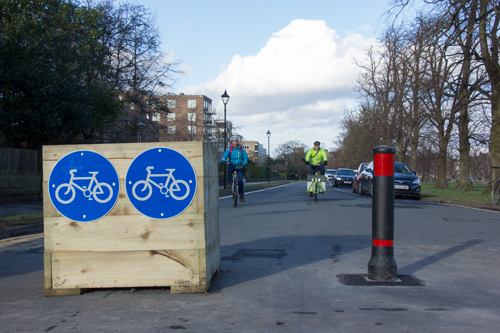
Signing Schedule

There is already some signage, but when the other measures outlined here are taken to create a branded, high-quality Cricket Ground Quietway, the signage should be branded and improved.
It ought to be a package, with everything done together – it’s not worth just doing the cheap/easy bit involving signs and leaving out the physical infrastructure measures. As stated in para. 13.7.5 of LTN1/20, the presence of a signed route may create an expectation in users that that route will provide a certain level of service. Poor provision will undermine trust in the signed network.
The principles relating to signage in LTN1/20 are set out in Chapter 13.
Re-use Existing Signs and Posts Where Possible

Many existing signs can be retained, perhaps with a branding patch added. A few new signs are needed – notably from the Mallinson Estate, as envisaged by para. 13.7.6, LTN1/20.

Schedule
Section 13.9 of LTN1/20 sets out how to prepare a signing schedule. It would be on the lines of the table below, but a little more detailed and with a few more technical elements such as GPS coordinates.
| Location | Sign |
| Various, within Mallinson Estate | Branded signs promoting Cricket Ground Quietway. Can include journey time in minutes (para. 13.6.2 LTN1/20) |
| Junction of Mallinson Oval and Leadhall Lane | Sign towards Leadhall Drive |
| Junction of Leadhall Crescent and Leadhall Lane | Sign towards Leadhall Drive |
| Junction of Leadhall Lane and Leadhall Drive | Sign towards the Cricket Ground/towards Mallinson Estate in opposite direction |
| Two path entrances to Cricket Ground | Branded signs including distance or time to town centre |
| By Club House | Sign towards Cricket Club exit |
| Exit of Cricket Ground | Sign right on St George’s Road |
| Junction of St George’s Road and Park Avenue | Sign left on Park Avenue |
| Junction of Park Avenue and Westbourne Avenue | X Remove incorrect signage to town centre that directs people down Westbourne Avenue |
| Junction of Park Avenue and Park Road | Sign towards town centre with distance or minutes Sign Cricket Ground and Mallinson Estate in other direction |
| Otley Road | Sign town centre on Beech Grove |
Branding
Branding is useful for routes radiating from the town centre.

The branding on signs can be patches.

Route identifiers such as numbers and colours are of little benefit without an accompanying map (para. 13.11.3, LTN1/20).
Signing should be done on the basis of a route map. It could be on the lines of this Harrogate Cycle Tube map.

Or Harrogate Borough Council’s Buy Local By Bike map could form the basis of route names and numbers.
Maintenance
Routine maintenance of cycle tracks should include regular sweeping (para. 15.6.1 LTN1/20).
One issue on this route is broken glass near the Cricket Ground Club House. It could be that glass recycling bins are placed here, and broken glass tends to drop from the bins onto the path. Regular sweeping would solve this problem.