


We have extracted the second Harrogate Transport Improvement Programme Report, HTIP2, from North Yorkshire Council (NYC). It was finalised in January 2025.
It needed a Freedom of Information request and a complaint to the Information Commissioner’s Office in order to force NYC to give us the report.
Background to HTIP

The HTIP project was started by the council in response to the 2019 Congestion Study, in which 77% of 15,500 respondents said they wanted better cycling and walking facilities in Harrogate & Knaresborough.
NYC has since spent £459,186 on consultants and produced no results.
In December 2025, NYC produced a short briefing about the contents of HTIP2, but refused to publish the full report.
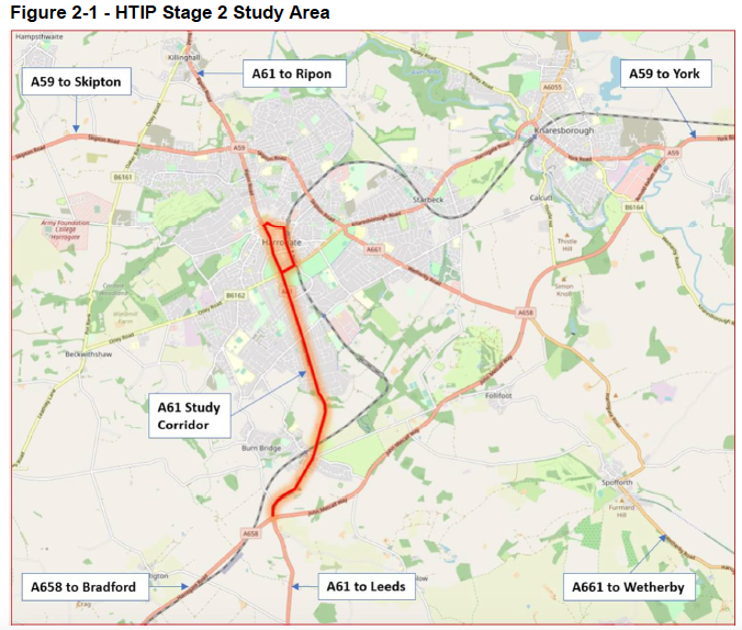
HTIP is a project supposedly looking into multi-modal interventions on the A61 Leeds Road south of Harrogate and through town as far as King’s Road.
The HTIP2 Report
The HTIP2 report is divided into these sections.
- Introduction
- Site Assessment
- Stakeholder Engagement
- Park & Ride Summary
- Scheme Development & Optioneering
- Short-Listed Options
- Cycle Improvement Options
- Cost Estimates
- Carbon Assessment & Management
- Impact Assessment
- Conclusion and Recommendations
1) Introduction
The Introduction recounts the history of WSP’s work, from the discarded so-called Harrogate Relief Road through HTIP1 and 2.
They started work on HTIP2 in June 2022 and presented outputs to NYC in August 2023.
2) Site Assessment
The Site Assessment section gives information about traffic volumes (Annual Average Daily Flow).
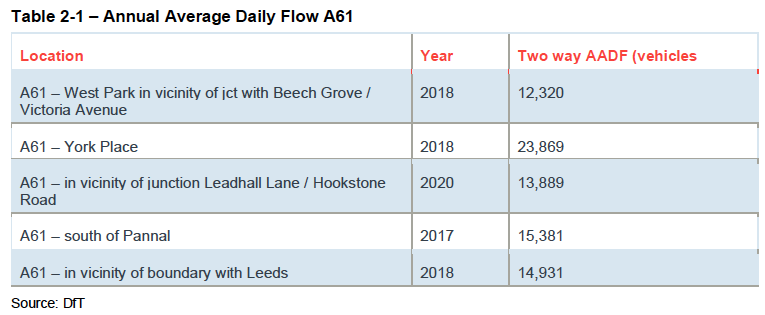
Buses and coaches represent only 1% of vehicles. Pedal cycles are also 1%.
‘The DfT’s AADFs indicate a high level of car use, particularly compared with cyclists and buses. Pedestrian movements are not included within these counts.
This suggests that interventions is required to help encourage a sustainable mode shift away from private vehicles to alternative, cleaner modes such as bus, cycling and walking’ (para 2.4.4).
The report notes (para 2.5.1) that Harrogate has made some progress in identifying priority areas and routes for improvements to the cycle network ‘but implementation has been slower’.
‘[T]here is still untapped potential for further enhancements, including the creation of more cycling-friendly routes, the integration of innovative technologies, and fostering a cycling culture that encourages more individuals to embrace this mode of transportation’ (para 2.5.1).
WSP note a high number of collisions along the A61 corridor, some of them involving people on bikes, and the lack of dedicated cycling infrastructure.
3) Stakeholder Engagement
It always surprises me that internal discussions among NYC staff are regarded as ‘stakeholder engagement’, but here we are again: the report talks about ‘engagement with key stakeholders within NYC through a series of meetings and workshops’.
WSP also did an online travel preferences survey with respondents who don’t work for the council.
They ‘fused’ the responses to the survey with Experian Mosaic demographic data, then took a Mobility Insights approach to analysing it.
One interesting result in the report is Willingness to Cycle.
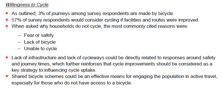
Fear of safety due to lack of infrastructure and cycleways is one of the key reasons some people don’t cycle.
77% of households suggested they would be willing to use Park & Ride.
WSP say that P&R would need to be cheaper than private vehicle travel into Harrogate, meaning subsidising the bus or increasing town centre parking costs.
4) Park & Ride Summary
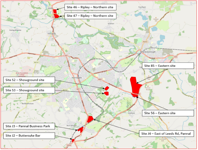
The consultants started with a list of 102 possible P&R sites, then whittled them down.
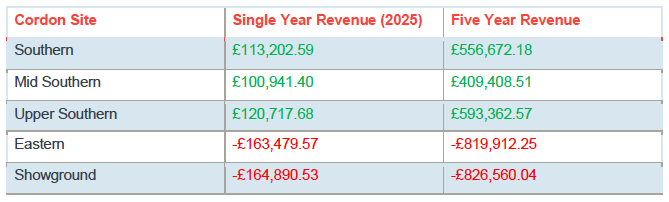
Southern sites along the A61 were the most promising. Adapting the existing 36 bus service was more financially viable than providing a dedicated service.
5) Scheme Development and Optioneering
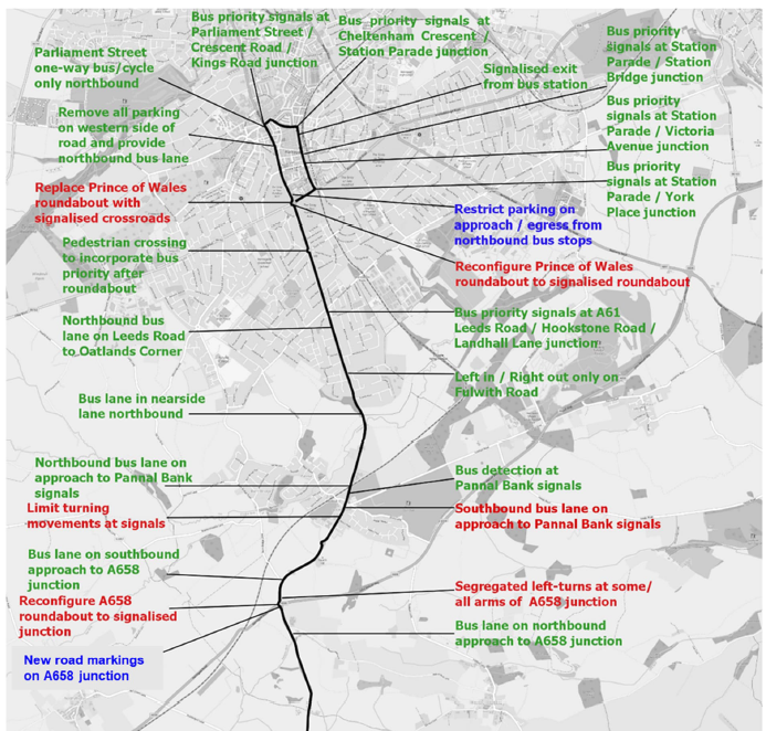
This section of the report says that the purpose of HTIP is to develop a series of complementary, multimodal interventions with consideration of bus priority, cycling and walking, and junction improvements (para 5.1.1).
‘The interventions are aimed at improving connectivity into and around Harrogate town centre, by sustainable modes of travel, contributing to NYC’s net zero goals, reducing congestion, and supporting economic growth’ (para 5.1.2).
While this is the stated objective, in practice in North Yorkshire work on sustainable options is generally wasted, as the council picks out the ‘increasing capacity for motor vehicle’ elements of reports and shelves the rest.
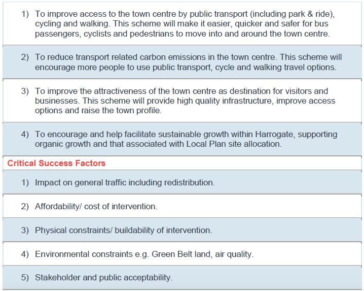
Theoretically, these are the objectives of HTIP and the Critical Success Factors.
WSP focused on the A61 corridor for bus improvements because there are proposals for a cycle link along the A59 which compete for space on that road (5.2.7).
Para 5.3.6 explains Do Minimum (a simple change e.g. to signal staging), Do Something (higher cost, e.g. banned turning movements), and Do Maximum (large scale and costly physical interventions).
6) Short-Listed Options
WSP looked at junctions along the A61 using traffic surveys from November 2022.
They also tested their options against estimated traffic volumes for 2033 in the West Harrogate Transport Strategy.
Kings Road Junction
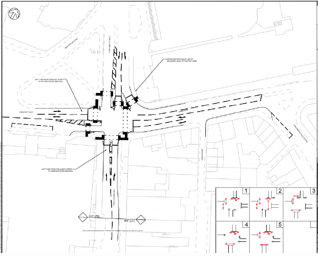
At the King’s Road, WSP recommend their Do Something option which would involve:
- banning left turns from Parliament Street to Crescent Road
- banning left turns from Crescent Road to the A61 northbound
- slightly wider pavements
Prince of Wales Roundabout to Parliament Street
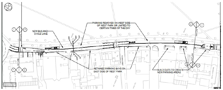
On this section of the A61 West Park WSP suggest removing car parking to create a 4.5m wide bus and cycle lane.
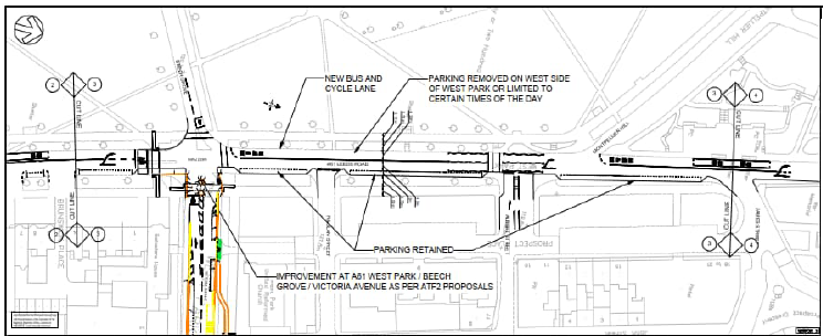
North of Cambridge Road there would be wider pavements.
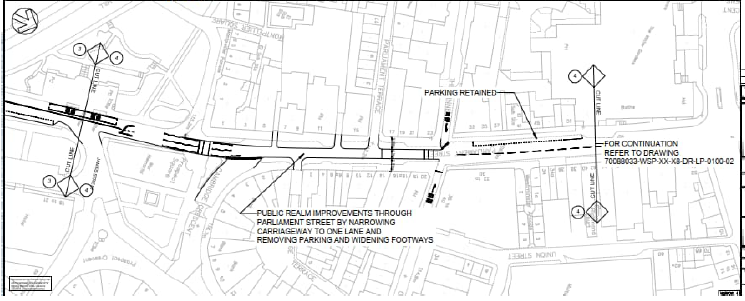
Note that the Parliament Street proposal would be incompatible with the LCWIP cycle route from Jennyfield along the A61 Ripon Road to the town centre, also drawn up by consultants WSP.
Prince of Wales Roundabout
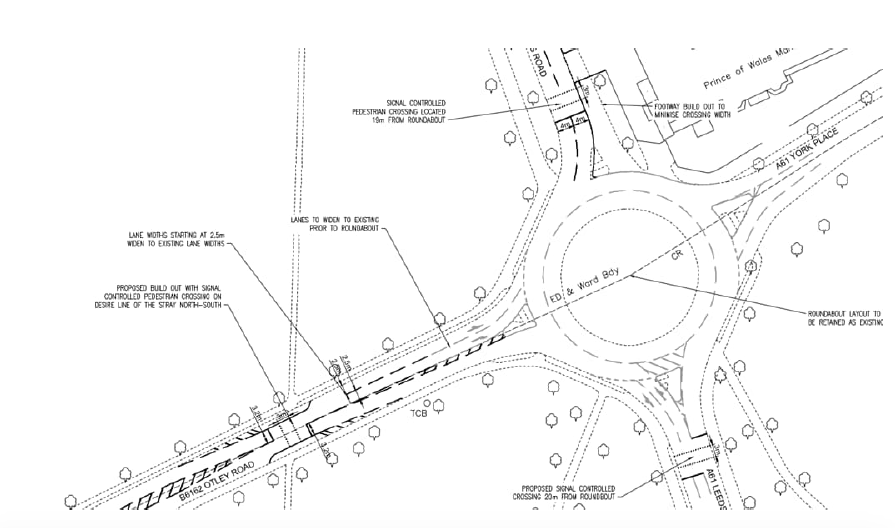
WSP’s options are:
- Do Something – signalised pedestrian crossings
- Do Maximum – a crossroads instead of the roundabout, with light-controlled pedestrian crossings; turning Trinity Road into an officially-approved rat run. (The report states that this option performs poorly from a traffic capacity point of view)
St George’s Roundabout (called Park Drive Roundabout in HTIP2)
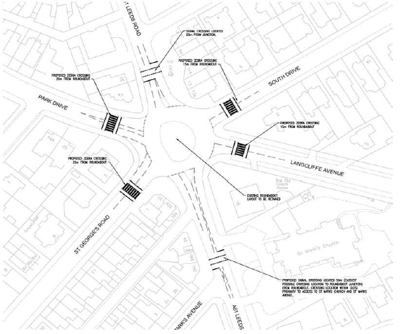
WSP’s options involve:
- Do Something – pedestrian crossing facilities of the roundabout arms
- Do Maximum – replace the roundabout with a four-arm signalised crossroads; modal filters on St George’s Road and South Drive, improving the cycle route
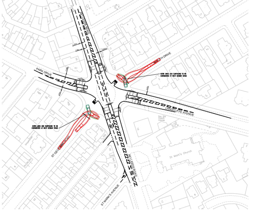
Do Maximum is the best in terms of traffic modelling/reducing saturation of the junction.
Leadhall Lane/Hookstone Road Junction
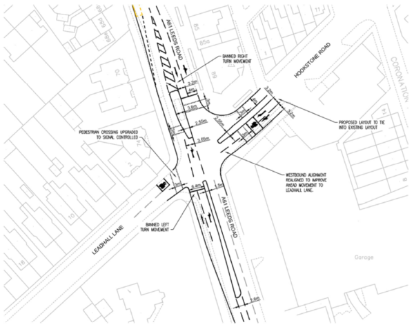
WSP only developed one option for this junction which involves:
- removal of A61 northbound left hand lane
- banning right turns into Leadhall Lane
- light-controlled pedestrian crossing of Leadhall Lane
Among WSP’s suggested alternatives to a right turn into Leadhall Lane is rat-running along Firs Crescent and Mallinson Oval, which is not on.
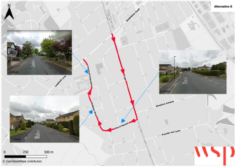
The principle should be that through traffic stays on main roads which are adapted to carry it.
If the consultants think it’s a good idea to encourage rat-running on residential streets, there’s a problem with their mindset.
Pannal Bank to Leadhall Lane
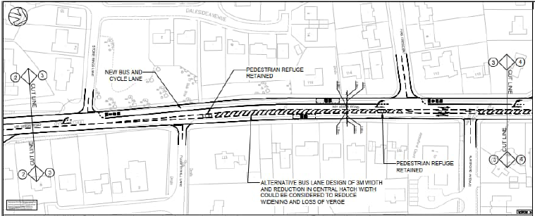
WSP suggest a bus lane for 1.25km up Pannal Bank, ending 100m before the Leadhall Lane junction.
Depending on the width of the bus lane, the central hatching and right turn pockets could be retained or removed.
Pannal Bank Junction
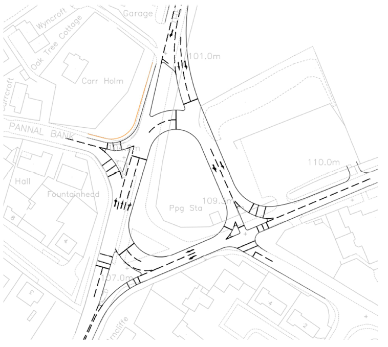
WSP’s options are:
- Do Something – ban right turn into Follifoot Road and right turn into Pannal Bank; WSP’s alternative routes involve rat-running along unsuitable roads
- Do Maximum – traffic light-controlled roundabout. It would be expensive and only has limited benefits
7) Cycle Improvement Options
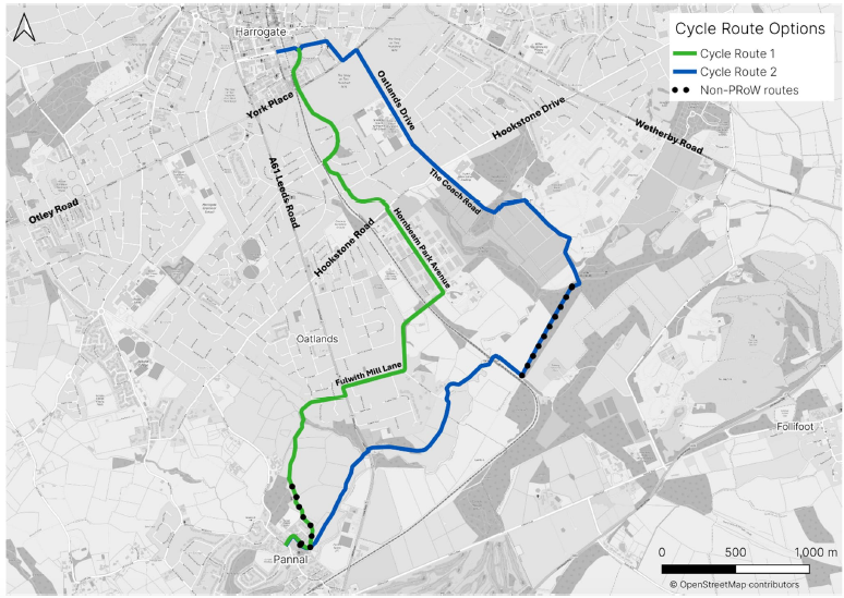
WSP say that road width probably prevents on-road cycle facilities (para 7.1.1).
Instead, they propose two off-road/quiet street routes from Pannal to Harrogate town centre largely for leisure cycling.
As mentioned in a previous article, I would not want to dismiss them entirely but they have severe drawbacks.
For utility cycling, a direct, well-lit route is needed. Further, for modal shift to cycling, the priority should be the built-up area closer to the town centre.
It is hard to imagine NYC, who have great difficulty delivering any on-the-ground improvements for cycling, ever building either of these routes.
7) Cost Estimates
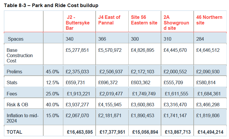
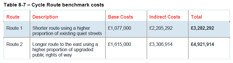
This section sets out various estimated costs.
I include the estimates for P&R above, and for the cycle routes below.
9) Carbon Assessment & Management
National and regional carbon targets require modal shift away from private vehicles, to active travel and public transport.
WSP didn’t do a full carbon assessment of the options, but applied a Red-Amber-Green rating system to the options’:
- strategic fit with decarbonisation plans
- user emissions and
- infrastructure carbon
10) Impact Assessment
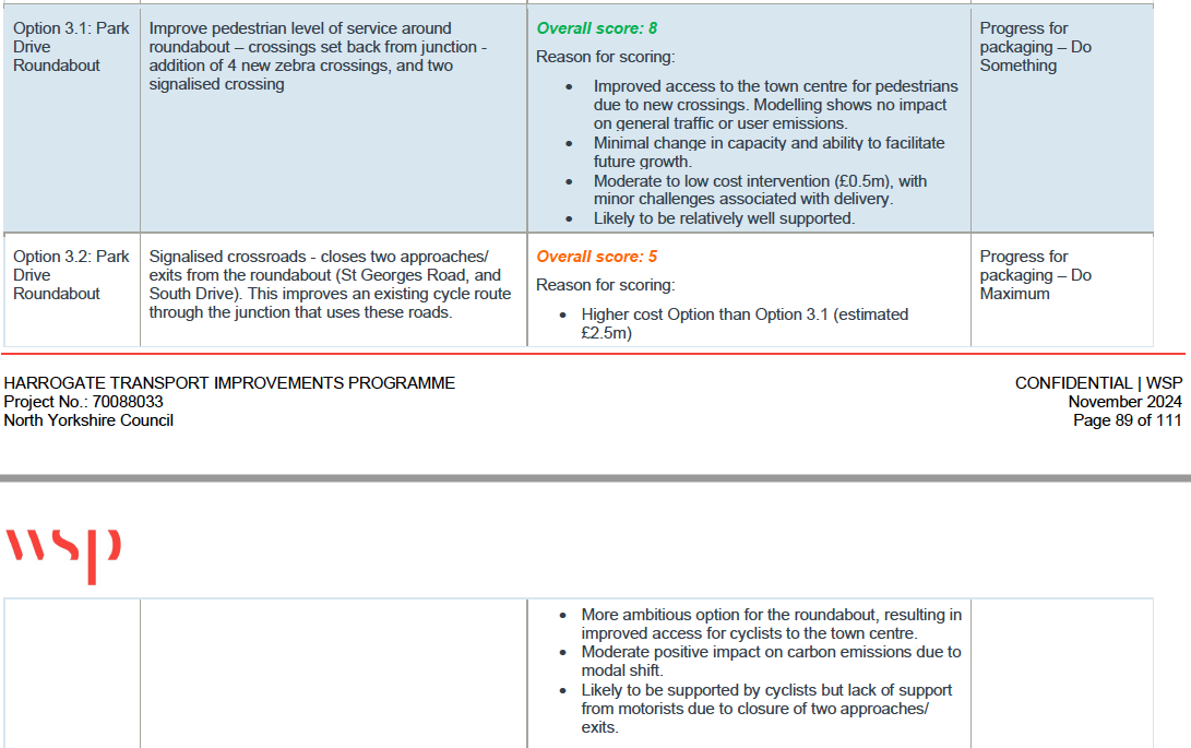
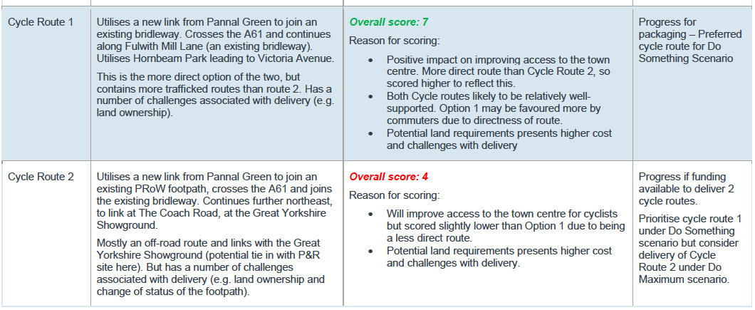
A Multi-Criteria Assessment Tool (MCAT) was used to assess the Value for Money of the different options and their strategic fit with the objectives of HTIP.
As an example, the image above shows the scoring for the two St George’s roundabout options.
The image below shows the scoring for the two cycle routes.
Also in this section, WSP organise their options into three packages:
- Do Minimum (£1.8 million)
- Do Something (£8.9 million) and
- Do Maximum (£31.5 million)
The image at the top of the page summarises the Do Maximum interventions.
11) Conclusion and Recommendations
The conclusion is that NYC now has the three packages of options.
The recommended next steps include:
- engaging with stakeholders
- planning discussions
- public consultation
- design development
- light-touch strategic case
- TAG scheme appraisal
In practice NYC’s next step has been to try to keep the report secret.