We have undertaken a comprehensive survey of Harrogate’s cycle network (the town, not the District). Our sugestions for bringing it up to a good standard are in our Harrogate Cycle Infrastructure Plan, which is organised by zones.
We have shared all the zone plans with North Yorkshire County Council (NYCC), and we hope the result will be that they produce and adopt a more detailed and ambitious Local Cycling & Walking Infrastructure Plan (LCWIP). Nevertheless these are our documents, not NYCC’s, and therefore should not be regarded as agreed council strategy or policy.
Users Manual
- The routes are based on the Cycle Network Map produced by consultants WSP for North Yorkshire County Council. The map is part of NYCC’s Harrogate Cycle Infrastructure Plan, so is agreed and accepted by them. We have made it easier to consult by adding the routes (plus a few extra ones in blue) to a Google map.
- We welcome comments about the zone plans; please give us your views in the comments section of the relevant zone page.
- You need to be logged in to comment.
Zone 1 South of Otley Road

Zone 1 covers the area immediately south of Otley Road.
Go to Zone 1.
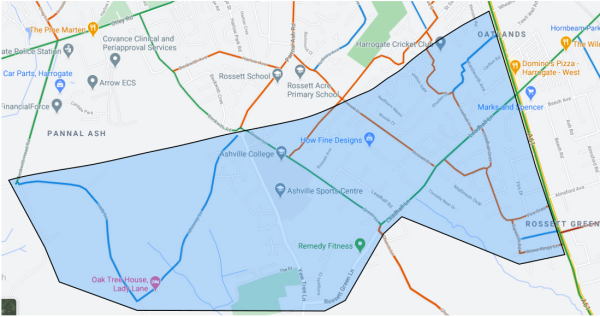
Zone 2 Leadhall Lane & Green Lane

Zone 2 is south of Zone 1, and includes Leadhall Lane, Green Lane, and Yew Tree Lane.
Go to Zone 2.
Zone 3 Leeds Road

Zone 3 is the Leeds Road corridor between Harrogate and Pannal.
Go to Zone 3.
Zone 4 North of Hookstone Road & Drive

Zone 4 is north of Hookstone Road and Drive, and includes Oatlands Drive and the areas either side of it.
Go to Zone 4.
Zone 5 Otley Road

Zone 5 is Otley Road from the Prince of Wales roundabout to Beckwithshaw.
Go to Zone 5.
Zone 6 Dragon Road

Zone 6 includes Dragon Road and Coach Road.
Go to Zone 6.
Zone 7 South of Hookstone Road & Drive

Zone 7 includes the bridleway past Oatlands Junior School, Hornbeam Park Avenue, the Yorkshire Showground Greenway, and the route to Spofforth.
Go to Zone 7.
Zone 8 Wetherby Road

Zone 8 is Wetherby Road from the Forest Lane junction to the Empress roundabout.
Go to Zone 8.
Zone 9 Stonefall Park

Zone 9 is a triangle centred on Stonefall Park, and includes Forest Lane and Hookstone Chase.
Go to Zone 9.
Zone 10 Fairfax & South Starbeck

Zone 10 is the area north of Hookstone Chase and Wetherby Road, and south of the A59.
Go to Zone 10.
Zone 11 Starbeck Forest Lane & A59

Zone 11 covers Starbeck, the A59 and Forest Lane.
Go to Zone 11.
Zone 12 Starbeck

Zone 12 is central Starbeck plus Bogs Lane and Kingsley Road.
Go to Zone 12.
Zone 13 Kingsley Drive & Claro Road

Zone 13 is the area north of the A59, including Kingsley Drive and Claro Road.
Go to Zone 13.
Zone 14 Jennyfield Area

Zone 14 is the Jennyfield area, including the A59 Skipton Road and Jennyfield Drive.
Go to Zone 14.
Zone 15 Woodfield Road

Zone 15 is the area around Woodfield Road.
Go to Zone 15.
Zone 16 Bilton

Zone 16 is Bilton, including part of the A59 and Bilton Lane.
Go to Zone 16.
Zone 17 New Park

Zone 17 is New Park roundabout and an area east of the roundabout including part of the A59 Skipton Road.
Go to Zone 17.
Zone 18 Cold Bath Road

Zone 18 is Cold Bath Road.
Go to Zone 18.
Zone 19 the Duchy

Zone 19 is the Duchy.
Go to Zone 19.
Zone 20 Harlow Moor Road & Penny Pot Lane

Zone 20 is Harlow Moor Road and Penny Pot Lane.
Go to Zone 20.
Zone 21 Kings Road

Zone 21 is Kings Road and nearby streets.
Go to Zone 21.
Zone 22 Ripon Road

Zone 22 is Ripon Road from the New Park roundabout to the War Memorial.
Go to Zone 22.
Zone 23 York Place

Zone 23 is York Place, SouthPark Road, North Park Road, the east end of Victoria Avenue, and Queen Parade.
Go to Zone 23.
Zone 24 Station Parade

Zone 24 is Cheltenham Parade, Station Parade, and other streets in this area.
Go to Zone 24.
