
This is an outline for our presentation to Harrogate Town Council (HTC).
This post is structured as follows:
- About Harrogate Cycle Action
- Planning a cycle network in Harrogate
- Types of infrastructure
- Obstacles to progress
- Housing development
- Summary
- What can HTC do?
1) About Harrogate Cycle Action
When and why we were set up, and what we do.
Our efforts to work with the highways authority, North Yorkshire Council (NYC).
Our 360 supporters and our Newsletters.
2) Planning a Cycle Network in Harrogate
A) Local Cycling and Walking Infrastructure Plan (LCWIP)
NYC has a Harrogate & Knaresborough LCWIP from 2019.
The cycling element of it identifies five priority corridors for cycling improvements. Four of them were for NYC to progress.

The plans sat on a shelf gathering dust for 6 years, but NYC has belatedly started looking at one of the routes.
Harrogate Borough Council (HBC) was responsible for the fifth route – High Bridge Knaresborough to Cardale Park.

In 2017 the councils got funding for an Otley Road Cycleway, which was part of that route. Nine years later we have just one isolated fragment of it.
B) Cycle Network Map
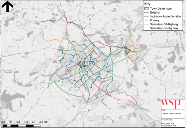
A cycle network map is part of the LCWIP.
It shows all the routes in Harrogate and Knaresborough which the council regards as potential cycle routes, and which should be improved to make them cycle-friendly.
The LCWIP provides no details about the improvements required, so we decided to do the work for them.
C) Zone Plans

What we did:
- split Harrogate up into zones
- cycled all the routes on the cycle network map, taking measurements
- applied LTN 1/20 Cycle Infrastructure Design (national design standards) in order to come up with proposals
Meetings with NYC Transport Planner Alex Kay to go through the proposals which resulted in NYC’s Harrogate Cycle Network Prioritisation document.
D) NYC’s Harrogate Cycle Network Prioritisation

NYC has produced a Cycle Network Prioritisation document.
There are:
- short-term priorities (red)
- medium-term priorities (blue) and
- long-term priorities (pink-purple)
The top priority was a coherent route Otley Road > Beech Grove > Victoria Avenue > Station Parade. (This route is still shown on NYC’s Harrogate Active Travel Projects map).
Unfortunately the council abandoned Otley Road Phase 2 and Beech Grove despite majority support for going ahead, resulting in the yellow smudge on the priorities map where cycle facilties should be.
That’s why we have lost confidence in NYC’s priorities work – there is no genuine commitment to delivering the routes they have theoretically prioritised.
One of the Core Design Principles in LTN 1/20 is that cycle routes should join up to make a coherent network.

E) Seville
Seville is a good example of a city that successfully built a cycle network. The main lessons from what they did are:
- build a basic network in a short time (18 months)
- it works
- people see that it works and they support what you did
3) Types of Infrastructure
The types of cycle infrastructure needed are set out in Figure 4.1 of LTN 1/20, and what’s required depends on traffic speed and volume.

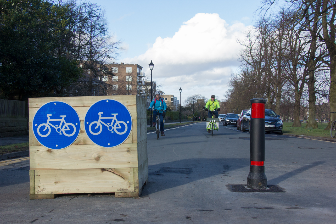
Cycle infrastructure includes kerb-protected cycle tracks or stepped cycle tracks on main roads.

Light segregation for lower speeds and traffic volumes.

[Painted cycle lanes – often worse than nothing because they lead to close passes, especially when they are well below the minimum widths as in most places in Harrogate.]

Modal filters – cheap, and very effective at stopping rat-running through traffic, while still allowing residents to drive to their houses.
Needs commitment from the council as there will be some objections.
Modal filters can be classed as ‘carrot and stick’ interventions, which are more effective at achieving modal shift than carrot-only approaches.
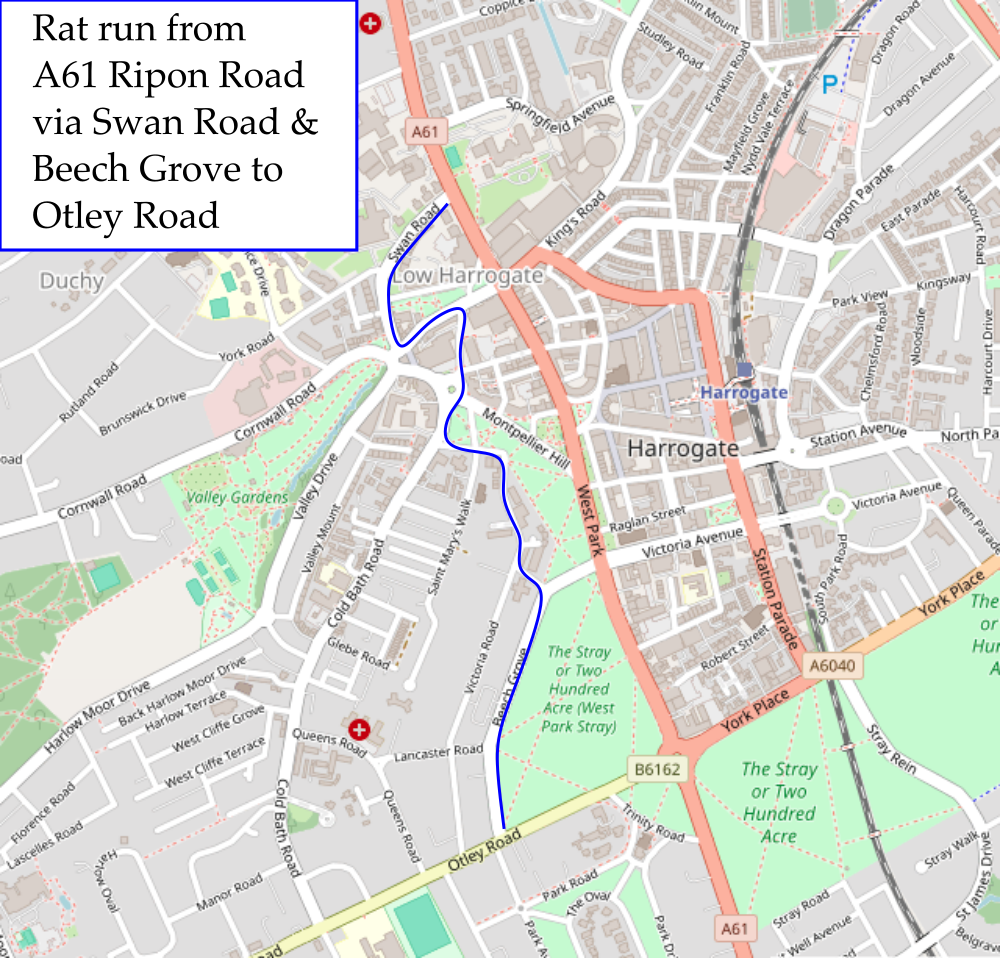
Example of problematic rat run:
How to Create Space for Cycling
Space for these types of infrastructure doesn’t just magically appear. In some cases it may need:
- removal of some parking spaces
- removal of general traffic lanes (e.g. original plans to reduce Station Parade from two lanes to one)
- making a road one way for motor vehicles
- modal filters
This requires political will!
4) Obstacles to Progress
The main obstacles to progress in creating a cycle network in Harrogate/North Yorkshire result from NYC:
- lack of political will
- prioritising movement of motor vehicles to the exclusion of active travel
- related to (2) above, slavishly following traffic modelling
- officer-led authority – no active travel strategy from NYC Executive
- lack of officer capacity (time and skills)
- related to (5), Active Travel Team still not set up
- excessive use of consultants (wastes time and money)
- extremely slow scheme delivery, gives opponents multiple opportunities to object/start legal action
This is reflected in NYC’s low Active Travel Capability rating – Level 1 on a scale of 0-4. (There are no Level 0 councils).
5) Housing Development
There has been a lot of housing development in Harrogate in recent years.
According to the National Planning Policy Framework, walking and cycling are supposed to be the top priority for transport improvements at new developments.
In practice, NYC prioritises motor vehicles, and pays lip service only to cycling.
Examples:
- King Edwin Park, Penny Pot Lane
- Dunlopillo Pannal
- Killinghall
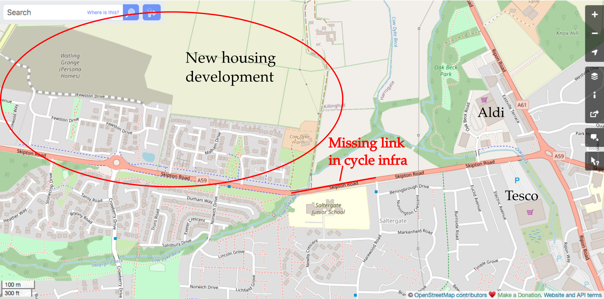
- A59 Skipton Road (pictured above – no link from all the new housing to the nearest supermarkets)
West Harrogate Urban Expansion

The Transport Strategy for West Harrogate urban expansion runs to 2036 and will have a big impact on our town.
The main points are:
- it is a ‘predict and provide’ strategy for motor vehicles, with capacity increases at 30 junctions across Harrogate
- widening junctions for motor vehicles will take all the space, and prevent cycling infrastructure being built
- there’s to be some cycle infrastructure on the development sites themselves
- the off-site cycle infrastructure is very disappointing – no link to the key destination, the town centre, because NYC cancelled Phase 2 of Otley Road Cycleway
Trinity Road

One of the most upsetting elements of NYC’s West Harrogate plans is their threat to turn Trinity Road into an official rat run/part of the main road network.
This is without asking any local residents, and without any democratic input.
It would prevent Trinity Road being used as a cycle link between future facilities on Leeds Road and Otley Road.
Induced Demand
When you increase capacity for motor vehicles, hoping to reduce congestion, all you actually do is increase the volume of motor vehicle traffic through ‘induced demand’.
Our region’s Routemap to Carbon Negative says we need to reduce traffic.
HTIP

The Harrogate Transport Improvement Programme (HTIP) overlaps with West Harrogate.
HTIP was supposed to be NYC’s response to the 2019 H&K Congestion Survey, in which 77% of 15,500 respondents asked for better walking and cycling facilities.
After 7 years and £459,000 spent on consultants, walking and cycling have been marginalised, and HTIP has resulted in no on-the-ground improvements.

6) Summary
Summary of the presentation.
- About Harrogate Cycle Action
- Planning a cycle network in Harrogate
- Types of infrastructure
- Obstacles to progress
- Housing development
- Summary
- What can HTC do?
7) What Can HTC Do?
HTC’s could:
- ask NYC to deliver specific cycle routes
- press for high standards
- keep NYC to timetable
Priority routes should include:
- the Knaresborough to Cardale Park LCWIP route
- related to that route, Beech Grove
- the Bilton-Hornbeam Park LCWIP route
- the missing link between new housing on the A59 Skipton Road and Tesco/Aldi
HTC should also influence transport plans for the West Harrogate urban expansion.
There are more Cycling Suggestions for Harrogate Town Council here.